

Latest Version
Version
1.6
1.6
Update
August 26, 2025
August 26, 2025
Developer
COREMAP CTI LIPI
COREMAP CTI LIPI
Categories
Tools
Tools
Platforms
Android
Android
Downloads
2
2
License
Free
Free
Package Name
com.andartafkh.makapa
com.andartafkh.makapa
Report
Report a Problem
Report a Problem
More About MonMang (No Longer Maintained)
This version of MonMang is no longer maintained. Please switch to MonMang 2 to get the latest version.
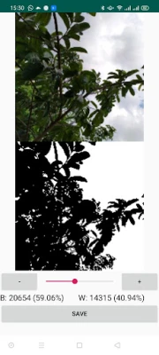
MonMang is a mobile app used for mangrove community structure field studies. This app offers an enjoyable new experience in recording data as a result of measurements in mangrove forests using a smartphone. In the same time, MonMang also helps users to analyze all of recorded data in the same time while recording. It also is able to make an final interpretation on mangrove health based on selected forest parameters in the measurement area.
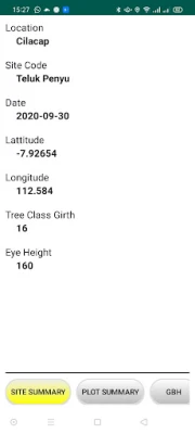
MonMang facilitates some features such as geographical position, time, tree-sapling GBH adjustment standard, camera hemispherical photography, height estimation which are needed for all activities during data collecting.
For More Information, please contact us
I WAYAN EKA DHARMAWAN, Research Centre for Oceanography
[email protected]
ANDARTA FARDHANUL KHOIR, Centre for Data and Scientific Documentation
[email protected]
Indonesian Institute of Sciences
Rate the App
Add Comment & Review
User Reviews
Based on 0 reviews
No reviews added yet.
Comments will not be approved to be posted if they are SPAM, abusive, off-topic, use profanity, contain a personal attack, or promote hate of any kind.


More »

Popular Apps

Chase MobileJPMorgan Chase

Perplexity - Ask AnythingPerplexityAI

Grand War 2: Strategy GamesJoynow Studio

Microsoft LauncherMicrosoft Corporation

Android Accessibility SuiteGoogle LLC

naccatechismNew Apostolic Church International

Voice AccessGoogle LLC

Sour & Dough - Bread BakingCoffee IT B.V.
Genesis ApologeticsBoundary Technology

Infant Games for 1-2 Year OldsTimpy Games For Kids, Toddlers & Baby
More »
Editor's Choice

Mind Echoes 1: Lost MysteriesDo Games Limited

The Elder Scrolls: CastlesBethesda Softworks LLC

Ring - Always HomeRing.com

Array by HamptonHampton Products International Corp

FleaMarketBay – Buy & SellFlea Market Bay LLC

Teon: Sword & MagicLakoo

KakaoPageKakao Entertainment Corp.

Kids Multiplication Math GamesRV AppStudios

Times Tables RaceMassimo Messore
Table Notes - Mobile ExcelSolution Developers